


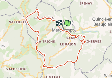
B9 Marchampt

jpfrobert
User

Length
20 km

Max alt
789 m

Uphill gradient
697 m
Km-Effort
29 km

Min alt
336 m

Downhill gradient
700 m
Boucle
Yes
Creation date :
2014-12-10 00:00:00.0
Updated on :
2014-12-10 00:00:00.0
1h52
Difficulty : Difficult

FREE GPS app for hiking
 SityTrail
IGN / Geographical institutes
SityTrail Plus
The world is yours!
About
Trail Mountain bike of 20 km to be discovered at Auvergne-Rhône-Alpes, Rhône, Marchampt. This trail is proposed by jpfrobert.
Positioning
Country:
France
Region :
Auvergne-Rhône-Alpes
Department/Province :
Rhône
Municipality :
Marchampt
Location:
Unknown
Start:(Dec)
Start:(UTM)
621450 ; 5107697 (31T) N.
Comments