


Largentiere Tauriers 13km

thonyc
User GUIDE
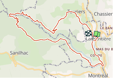

Length
14 km

Max alt
497 m

Uphill gradient
544 m
Km-Effort
21 km

Min alt
184 m

Downhill gradient
547 m
Boucle
Yes
Creation date :
2021-02-01 15:34:23.548
Updated on :
2021-02-01 15:42:55.649
5h03
Difficulty : Medium

FREE GPS app for hiking
 SityTrail
IGN / Geographical institutes
SityTrail Plus
The world is yours!
About
Trail Walking of 14 km to be discovered at Auvergne-Rhône-Alpes, Ardèche, Largentière. This trail is proposed by thonyc.
Positioning
Country:
France
Region :
Auvergne-Rhône-Alpes
Department/Province :
Ardèche
Municipality :
Largentière
Location:
Unknown
Start:(Dec)
Start:(UTM)
602501 ; 4932764 (31T) N.
Comments