DIFFICILECitadelle

clemsdpp
User
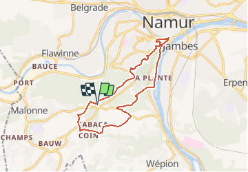

Length
12.8 km

Max alt
228 m

Uphill gradient
318 m
Km-Effort
17 km

Min alt
78 m

Downhill gradient
319 m
Boucle
Yes
Creation date :
2020-12-13 10:20:33.127
Updated on :
2021-03-04 20:45:04.779
--
Difficulty : Very easy

FREE GPS app for hiking
 SityTrail
IGN / Geographical institutes
SityTrail Plus
The world is yours!
About
Trail On foot of 12.8 km to be discovered at Wallonia, Namur, Namur. This trail is proposed by clemsdpp.
Positioning
Country:
Belgium
Region :
Wallonia
Department/Province :
Namur
Municipality :
Namur
Location:
Malonne
Start:(Dec)
Start:(UTM)
630018 ; 5589145 (31U) N.
Comments