


st Aygulf gaillarde

fab4u
User
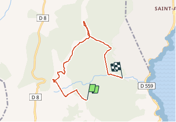

Length
6.7 km

Max alt
247 m

Uphill gradient
200 m
Km-Effort
9.9 km

Min alt
12 m

Downhill gradient
363 m
Boucle
No
Creation date :
2021-02-03 11:35:21.921
Updated on :
2021-02-03 14:50:37.04
3h14
Difficulty : Medium

FREE GPS app for hiking
 SityTrail
IGN / Geographical institutes
SityTrail Plus
The world is yours!
About
Trail Walking of 6.7 km to be discovered at Provence-Alpes-Côte d'Azur, Var, Roquebrune-sur-Argens. This trail is proposed by fab4u.
Positioning
Country:
France
Region :
Provence-Alpes-Côte d'Azur
Department/Province :
Var
Municipality :
Roquebrune-sur-Argens
Location:
Unknown
Start:(Dec)
Start:(UTM)
312950 ; 4803656 (32T) N.
Comments