


Xr0XVa-0IC4

thonyc
User GUIDE
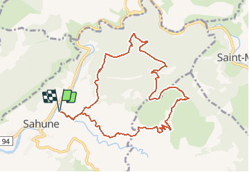

Length
10.7 km

Max alt
914 m

Uphill gradient
637 m
Km-Effort
19.2 km

Min alt
356 m

Downhill gradient
637 m
Boucle
Yes
Creation date :
2021-02-03 16:38:28.847
Updated on :
2021-02-03 16:39:23.656
4h00
Difficulty : Difficult

FREE GPS app for hiking
 SityTrail
IGN / Geographical institutes
SityTrail Plus
The world is yours!
About
Trail Walking of 10.7 km to be discovered at Auvergne-Rhône-Alpes, Drôme, Sahune. This trail is proposed by thonyc.
Positioning
Country:
France
Region :
Auvergne-Rhône-Alpes
Department/Province :
Drôme
Municipality :
Sahune
Location:
Unknown
Start:(Dec)
Start:(UTM)
680927 ; 4920676 (31T) N.
Comments