chahalot

noelphil
User
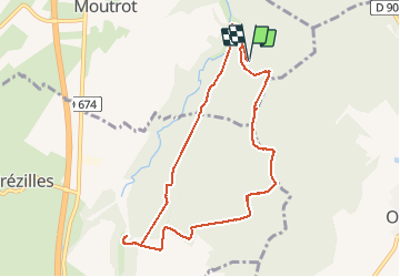

Length
8.6 km

Max alt
289 m

Uphill gradient
113 m
Km-Effort
10.1 km

Min alt
223 m

Downhill gradient
114 m
Boucle
Yes
Creation date :
2021-02-07 13:09:20.317
Updated on :
2021-02-08 07:46:07.211
2h06
Difficulty : Medium

FREE GPS app for hiking
 SityTrail
IGN / Geographical institutes
SityTrail Plus
The world is yours!
About
Trail Walking of 8.6 km to be discovered at Grand Est, Meurthe-et-Moselle, Moutrot. This trail is proposed by noelphil.
Description
Les deuilles
Positioning
Country:
France
Region :
Grand Est
Department/Province :
Meurthe-et-Moselle
Municipality :
Moutrot
Location:
Unknown
Start:(Dec)
Start:(UTM)
714979 ; 5386849 (31U) N.
Comments