


SityTrail - St max_12km

ZAMBAUX
User
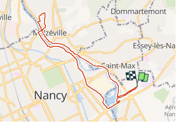

Length
8.9 km

Max alt
202 m

Uphill gradient
75 m
Km-Effort
9.9 km

Min alt
184 m

Downhill gradient
74 m
Boucle
Yes
Creation date :
2021-02-08 15:10:23.159
Updated on :
2021-02-08 15:11:34.58
2h14
Difficulty : Medium

FREE GPS app for hiking
 SityTrail
IGN / Geographical institutes
SityTrail Plus
The world is yours!
About
Trail Walking of 8.9 km to be discovered at Grand Est, Meurthe-et-Moselle, Tomblaine. This trail is proposed by ZAMBAUX.
Description
Rando très facile en bord de Meurthe
Positioning
Country:
France
Region :
Grand Est
Department/Province :
Meurthe-et-Moselle
Municipality :
Tomblaine
Location:
Unknown
Start:(Dec)
Start:(UTM)
294981 ; 5397347 (32U) N.
Comments