


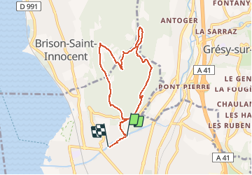
Croix de Corsuet

michel.pegaz
User

Length
7.3 km

Max alt
525 m

Uphill gradient
301 m
Km-Effort
11.3 km

Min alt
245 m

Downhill gradient
308 m
Boucle
No
Creation date :
2021-02-08 13:22:08.0
Updated on :
2021-02-09 08:45:36.898
2h07
Difficulty : Easy

FREE GPS app for hiking
 SityTrail
IGN / Geographical institutes
SityTrail Plus
The world is yours!
About
Trail Walking of 7.3 km to be discovered at Auvergne-Rhône-Alpes, Savoy, Aix-les-Bains. This trail is proposed by michel.pegaz.
Description
Chemin de la Bathiaz chemin du Loup Croix de Corsuet Ferme Raymond Beauregard le Sierroz
Photos


Positioning
Country:
France
Region :
Auvergne-Rhône-Alpes
Department/Province :
Savoy
Municipality :
Aix-les-Bains
Location:
Unknown
Start:(Dec)
Start:(UTM)
726137 ; 5065531 (31T) N.
Comments