


hautôt sur seine

dedejojo
User
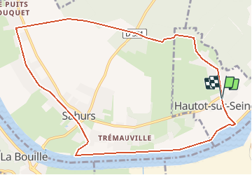

Length
10.8 km

Max alt
61 m

Uphill gradient
94 m
Km-Effort
12.1 km

Min alt
-2 m

Downhill gradient
93 m
Boucle
Yes
Creation date :
2021-02-08 17:11:24.54
Updated on :
2021-02-08 17:18:47.89
--
Difficulty : Very easy

FREE GPS app for hiking
 SityTrail
IGN / Geographical institutes
SityTrail Plus
The world is yours!
About
Trail On foot of 10.8 km to be discovered at Normandy, Seine-Maritime, Hautot-sur-Seine. This trail is proposed by dedejojo.
Positioning
Country:
France
Region :
Normandy
Department/Province :
Seine-Maritime
Municipality :
Hautot-sur-Seine
Location:
Unknown
Start:(Dec)
Start:(UTM)
353258 ; 5469592 (31U) N.
Comments