


Labbeville

avdem
User
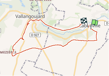

Length
9.7 km

Max alt
111 m

Uphill gradient
110 m
Km-Effort
11.2 km

Min alt
42 m

Downhill gradient
120 m
Boucle
Yes
Creation date :
2021-02-09 08:27:12.013
Updated on :
2021-02-09 10:47:14.679
2h19
Difficulty : Very easy

FREE GPS app for hiking
 SityTrail
IGN / Geographical institutes
SityTrail Plus
The world is yours!
About
Trail Walking of 9.7 km to be discovered at Ile-de-France, Val-d'Oise, Labbeville. This trail is proposed by avdem.
Description
froid
Positioning
Country:
France
Region :
Ile-de-France
Department/Province :
Val-d'Oise
Municipality :
Labbeville
Location:
Unknown
Start:(Dec)
Start:(UTM)
437663 ; 5442832 (31U) N.
Comments