


Santeny

DFAL
User
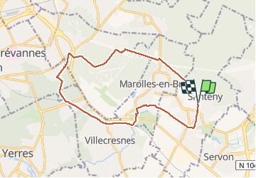

Length
14.9 km

Max alt
105 m

Uphill gradient
124 m
Km-Effort
16.6 km

Min alt
58 m

Downhill gradient
125 m
Boucle
Yes
Creation date :
2021-02-09 08:19:12.0
Updated on :
2021-02-09 11:18:08.058
2h58
Difficulty : Unknown

FREE GPS app for hiking
 SityTrail
IGN / Geographical institutes
SityTrail Plus
The world is yours!
About
Trail Walking of 14.9 km to be discovered at Ile-de-France, Val-de-Marne, Santeny. This trail is proposed by DFAL.
Positioning
Country:
France
Region :
Ile-de-France
Department/Province :
Val-de-Marne
Municipality :
Santeny
Location:
Unknown
Start:(Dec)
Start:(UTM)
468783 ; 5397846 (31U) N.
Comments