


etang de suze

losjo
User
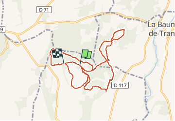

Length
11.2 km

Max alt
151 m

Uphill gradient
131 m
Km-Effort
13 km

Min alt
95 m

Downhill gradient
133 m
Boucle
No
Creation date :
2021-02-09 12:53:52.775
Updated on :
2021-02-09 16:01:04.404
3h06
Difficulty : Very easy

FREE GPS app for hiking
 SityTrail
IGN / Geographical institutes
SityTrail Plus
The world is yours!
About
Trail Walking of 11.2 km to be discovered at Auvergne-Rhône-Alpes, Drôme, Suze-la-Rousse. This trail is proposed by losjo.
Description
rando
Positioning
Country:
France
Region :
Auvergne-Rhône-Alpes
Department/Province :
Drôme
Municipality :
Suze-la-Rousse
Location:
Unknown
Start:(Dec)
Start:(UTM)
646187 ; 4910029 (31T) N.
Comments