


Décines-Biézin nature-Rhône

ThierryJ01
User
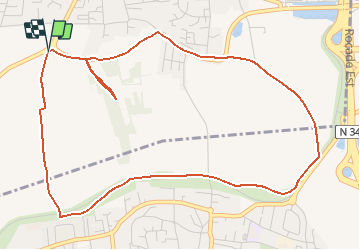

Length
6.1 km

Max alt
230 m

Uphill gradient
75 m
Km-Effort
7.1 km

Min alt
193 m

Downhill gradient
76 m
Boucle
Yes
Creation date :
2021-02-09 22:08:55.257
Updated on :
2021-02-09 22:09:44.617
1h36
Difficulty : Medium

FREE GPS app for hiking
 SityTrail
IGN / Geographical institutes
SityTrail Plus
The world is yours!
About
Trail Walking of 6.1 km to be discovered at Auvergne-Rhône-Alpes, Métropole de Lyon, Décines-Charpieu. This trail is proposed by ThierryJ01.
Positioning
Country:
France
Region :
Auvergne-Rhône-Alpes
Department/Province :
Métropole de Lyon
Municipality :
Décines-Charpieu
Location:
Unknown
Start:(Dec)
Start:(UTM)
652388 ; 5069059 (31T) N.
Comments