


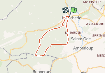
Lavacherie ter

pierlan
User

Length
10.9 km

Max alt
542 m

Uphill gradient
267 m
Km-Effort
14.4 km

Min alt
381 m

Downhill gradient
266 m
Boucle
Yes
Creation date :
2021-02-08 17:50:15.428
Updated on :
2021-02-10 19:25:34.602
3h20
Difficulty : Unknown

FREE GPS app for hiking
 SityTrail
IGN / Geographical institutes
SityTrail Plus
The world is yours!
About
Trail Trail of 10.9 km to be discovered at Wallonia, Luxembourg, Sainte-Ode. This trail is proposed by pierlan.
Positioning
Country:
Belgium
Region :
Wallonia
Department/Province :
Luxembourg
Municipality :
Sainte-Ode
Location:
Lavacherie
Start:(Dec)
Start:(UTM)
679770 ; 5547537 (31U) N.
Comments