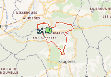
La Caumette- Pic du Tantajo

PiloudeBamako
User

Length
13 km

Max alt
505 m

Uphill gradient
427 m
Km-Effort
18.7 km

Min alt
270 m

Downhill gradient
427 m
Boucle
Yes
Creation date :
2021-02-11 08:23:28.0
Updated on :
2021-02-21 17:08:46.854
4h59
Difficulty : Difficult

FREE GPS app for hiking
 SityTrail
IGN / Geographical institutes
SityTrail Plus
The world is yours!
About
Trail Walking of 13 km to be discovered at Occitania, Hérault, Faugères. This trail is proposed by PiloudeBamako.
Description
Randonnée autour de Soumartre. Départ du hameau de La Causette. Montée au moulin de Faugères. Retour à La Causette par le Pic du Tantajo avec une belle vue plongeante sur Bédarieux.
Photos


Positioning
Country:
France
Region :
Occitania
Department/Province :
Hérault
Municipality :
Faugères
Location:
Unknown
Start:(Dec)
Start:(UTM)
513342 ; 4825691 (31T) N.
Comments