


autour de chapias

raab
User
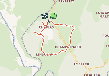

Length
6.5 km

Max alt
278 m

Uphill gradient
106 m
Km-Effort
8 km

Min alt
218 m

Downhill gradient
106 m
Boucle
Yes
Creation date :
2021-02-11 17:41:45.784
Updated on :
2023-10-30 15:42:28.434
1h48
Difficulty : Easy

FREE GPS app for hiking
 SityTrail
IGN / Geographical institutes
SityTrail Plus
The world is yours!
About
Trail On foot of 6.5 km to be discovered at Auvergne-Rhône-Alpes, Ardèche, Labeaume. This trail is proposed by raab.
Positioning
Country:
France
Region :
Auvergne-Rhône-Alpes
Department/Province :
Ardèche
Municipality :
Labeaume
Location:
Unknown
Start:(Dec)
Start:(UTM)
602650 ; 4925219 (31T) N.
Comments