


st sernin vogue

raab
User
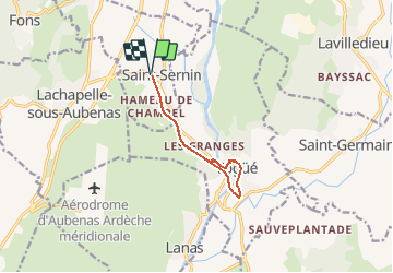

Length
8.7 km

Max alt
213 m

Uphill gradient
182 m
Km-Effort
11.2 km

Min alt
146 m

Downhill gradient
182 m
Boucle
Yes
Creation date :
2021-02-12 11:01:37.04
Updated on :
2021-02-12 11:02:24.543
--
Difficulty : Very easy

FREE GPS app for hiking
 SityTrail
IGN / Geographical institutes
SityTrail Plus
The world is yours!
About
Trail On foot of 8.7 km to be discovered at Auvergne-Rhône-Alpes, Ardèche, Saint-Sernin. This trail is proposed by raab.
Positioning
Country:
France
Region :
Auvergne-Rhône-Alpes
Department/Province :
Ardèche
Municipality :
Saint-Sernin
Location:
Unknown
Start:(Dec)
Start:(UTM)
610279 ; 4936195 (31T) N.
Comments