


2021-02-13_20h09m58_nevissac ailhon

raab
User
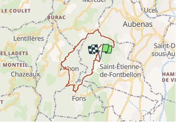

Length
13.8 km

Max alt
465 m

Uphill gradient
475 m
Km-Effort
20 km

Min alt
227 m

Downhill gradient
473 m
Boucle
Yes
Creation date :
2021-02-13 19:09:59.168
Updated on :
2021-02-13 19:51:43.773
--
Difficulty : Very easy

FREE GPS app for hiking
 SityTrail
IGN / Geographical institutes
SityTrail Plus
The world is yours!
About
Trail On foot of 13.8 km to be discovered at Auvergne-Rhône-Alpes, Ardèche, Saint-Étienne-de-Fontbellon. This trail is proposed by raab.
Positioning
Country:
France
Region :
Auvergne-Rhône-Alpes
Department/Province :
Ardèche
Municipality :
Saint-Étienne-de-Fontbellon
Location:
Unknown
Start:(Dec)
Start:(UTM)
608255 ; 4939708 (31T) N.
Comments