


ailhon grand tour

raab
User
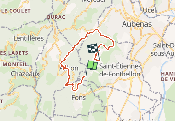

Length
12.9 km

Max alt
465 m

Uphill gradient
380 m
Km-Effort
18.1 km

Min alt
227 m

Downhill gradient
432 m
Boucle
No
Creation date :
2021-02-13 09:33:42.448
Updated on :
2021-02-13 19:15:37.74
5h54
Difficulty : Medium

FREE GPS app for hiking
 SityTrail
IGN / Geographical institutes
SityTrail Plus
The world is yours!
About
Trail Walking of 12.9 km to be discovered at Auvergne-Rhône-Alpes, Ardèche, Saint-Étienne-de-Fontbellon. This trail is proposed by raab.
Positioning
Country:
France
Region :
Auvergne-Rhône-Alpes
Department/Province :
Ardèche
Municipality :
Saint-Étienne-de-Fontbellon
Location:
Unknown
Start:(Dec)
Start:(UTM)
607472 ; 4938740 (31T) N.
Comments