


Col de la Ruchere depuis le Pont des Allemands - 14 février 2021

morganee
User
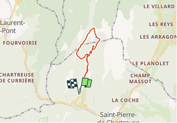

Length
11.3 km

Max alt
1436 m

Uphill gradient
623 m
Km-Effort
19.6 km

Min alt
821 m

Downhill gradient
630 m
Boucle
Yes
Creation date :
2021-02-14 09:04:07.737
Updated on :
2021-02-14 14:32:56.678
5h13
Difficulty : Easy

FREE GPS app for hiking
 SityTrail
IGN / Geographical institutes
SityTrail Plus
The world is yours!
About
Trail Snowshoes of 11.3 km to be discovered at Auvergne-Rhône-Alpes, Isère, Saint-Pierre-de-Chartreuse. This trail is proposed by morganee.
Description
Belle rando raquettes, beaucoup de vent froid au col
Positioning
Country:
France
Region :
Auvergne-Rhône-Alpes
Department/Province :
Isère
Municipality :
Saint-Pierre-de-Chartreuse
Location:
Unknown
Start:(Dec)
Start:(UTM)
718363 ; 5026107 (31T) N.
Comments