


Gare de St Amand à Valenciennes par Aremberg et Etang du Vignoble

dehemjacques
User
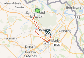

Length
25 km

Max alt
57 m

Uphill gradient
166 m
Km-Effort
27 km

Min alt
12 m

Downhill gradient
160 m
Boucle
No
Creation date :
2021-02-15 16:55:05.163
Updated on :
2021-02-15 16:56:02.27
5h00
Difficulty : Medium

FREE GPS app for hiking
 SityTrail
IGN / Geographical institutes
SityTrail Plus
The world is yours!
About
Trail On foot of 25 km to be discovered at Hauts-de-France, Nord, Saint-Amand-les-Eaux. This trail is proposed by dehemjacques.
Positioning
Country:
France
Region :
Hauts-de-France
Department/Province :
Nord
Municipality :
Saint-Amand-les-Eaux
Location:
Unknown
Start:(Dec)
Start:(UTM)
529800 ; 5588013 (31U) N.
Comments