


20210211_trentespas

ajd26
User
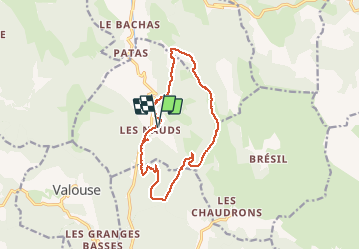

Length
15 km

Max alt
1383 m

Uphill gradient
878 m
Km-Effort
27 km

Min alt
657 m

Downhill gradient
878 m
Boucle
Yes
Creation date :
2021-02-16 08:17:31.421
Updated on :
2021-02-16 08:22:01.684
--
Difficulty : Unknown

FREE GPS app for hiking
 SityTrail
IGN / Geographical institutes
SityTrail Plus
The world is yours!
About
Trail Walking of 15 km to be discovered at Auvergne-Rhône-Alpes, Drôme, Chaudebonne. This trail is proposed by ajd26.
Description
le 11/02/2012
Positioning
Country:
France
Region :
Auvergne-Rhône-Alpes
Department/Province :
Drôme
Municipality :
Chaudebonne
Location:
Unknown
Start:(Dec)
Start:(UTM)
676654 ; 4927370 (31T) N.
Comments