


SityTrail - 2661455 - st-pons-plaine-du-regard-13km

thonyc
User GUIDE
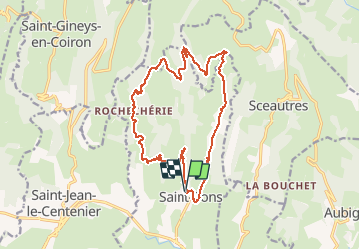

Length
17.9 km

Max alt
677 m

Uphill gradient
640 m
Km-Effort
26 km

Min alt
292 m

Downhill gradient
635 m
Boucle
Yes
Creation date :
2021-02-16 12:39:20.431
Updated on :
2021-02-17 08:37:38.825
5h10
Difficulty : Difficult

FREE GPS app for hiking
 SityTrail
IGN / Geographical institutes
SityTrail Plus
The world is yours!
About
Trail Walking of 17.9 km to be discovered at Auvergne-Rhône-Alpes, Ardèche, Saint-Pons. This trail is proposed by thonyc.
Positioning
Country:
France
Region :
Auvergne-Rhône-Alpes
Department/Province :
Ardèche
Municipality :
Saint-Pons
Location:
Unknown
Start:(Dec)
Start:(UTM)
625103 ; 4939016 (31T) N.
Comments