


2021-02-16_13h49m12_gpx-trace

raab
User
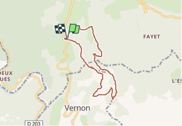

Length
7 km

Max alt
479 m

Uphill gradient
168 m
Km-Effort
9.3 km

Min alt
363 m

Downhill gradient
168 m
Boucle
Yes
Creation date :
2021-02-16 12:49:13.101
Updated on :
2021-02-16 12:58:28.743
--
Difficulty : Medium

FREE GPS app for hiking
 SityTrail
IGN / Geographical institutes
SityTrail Plus
The world is yours!
About
Trail On foot of 7 km to be discovered at Auvergne-Rhône-Alpes, Ardèche, Sanilhac. This trail is proposed by raab.
Positioning
Country:
France
Region :
Auvergne-Rhône-Alpes
Department/Province :
Ardèche
Municipality :
Sanilhac
Location:
Unknown
Start:(Dec)
Start:(UTM)
597050 ; 4930823 (31T) N.
Comments