


les tetines de vernon

raab
User
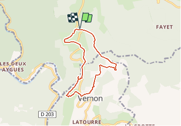

Length
6.8 km

Max alt
493 m

Uphill gradient
214 m
Km-Effort
9.7 km

Min alt
284 m

Downhill gradient
214 m
Boucle
Yes
Creation date :
2021-02-16 13:09:01.345
Updated on :
2021-02-16 13:10:52.52
--
Difficulty : Medium

FREE GPS app for hiking
 SityTrail
IGN / Geographical institutes
SityTrail Plus
The world is yours!
About
Trail On foot of 6.8 km to be discovered at Auvergne-Rhône-Alpes, Ardèche, Sanilhac. This trail is proposed by raab.
Positioning
Country:
France
Region :
Auvergne-Rhône-Alpes
Department/Province :
Ardèche
Municipality :
Sanilhac
Location:
Unknown
Start:(Dec)
Start:(UTM)
597041 ; 4930849 (31T) N.
Comments