


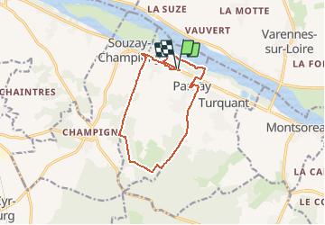
2021-02-16_15h16m37_Entre Loire et coteaux à Parnay

raab
User

Length
11.9 km

Max alt
104 m

Uphill gradient
140 m
Km-Effort
13.8 km

Min alt
27 m

Downhill gradient
141 m
Boucle
Yes
Creation date :
2021-02-16 14:16:38.043
Updated on :
2021-02-16 15:28:18.936
--
Difficulty : Very easy

FREE GPS app for hiking
 SityTrail
IGN / Geographical institutes
SityTrail Plus
The world is yours!
About
Trail On foot of 11.9 km to be discovered at Pays de la Loire, Maine-et-Loire, Parnay. This trail is proposed by raab.
Positioning
Country:
France
Region :
Pays de la Loire
Department/Province :
Maine-et-Loire
Municipality :
Parnay
Location:
Unknown
Start:(Dec)
Start:(UTM)
273745 ; 5235205 (31T) N.
Comments