


Creyseilles

raygautier
User

Length
65 km

Max alt
918 m

Uphill gradient
928 m
Km-Effort
79 km

Min alt
87 m

Downhill gradient
1385 m
Boucle
No
Creation date :
2021-02-17 07:36:32.0
Updated on :
2021-02-17 17:58:07.145
10h06
Difficulty : Unknown

FREE GPS app for hiking
 SityTrail
IGN / Geographical institutes
SityTrail Plus
The world is yours!
About
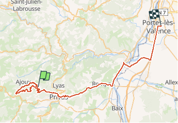
Trail Walking of 65 km to be discovered at Auvergne-Rhône-Alpes, Ardèche, Creysseilles. This trail is proposed by raygautier.
Positioning
Country:
France
Region :
Auvergne-Rhône-Alpes
Department/Province :
Ardèche
Municipality :
Creysseilles
Location:
Unknown
Start:(Dec)
Start:(UTM)
622219 ; 4956964 (31T) N.
Comments