


pont d'ouilly le chemin du roy

magny
User
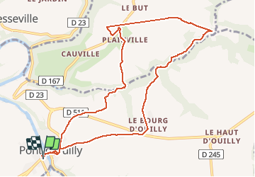

Length
10.7 km

Max alt
207 m

Uphill gradient
316 m
Km-Effort
15 km

Min alt
48 m

Downhill gradient
315 m
Boucle
Yes
Creation date :
2021-02-19 12:34:37.255
Updated on :
2021-02-19 15:22:45.847
2h07
Difficulty : Very easy

FREE GPS app for hiking
 SityTrail
IGN / Geographical institutes
SityTrail Plus
The world is yours!
About
Trail Walking of 10.7 km to be discovered at Normandy, Calvados, Pont-d'Ouilly. This trail is proposed by magny.
Description
très belle randonnée.
chaussures adaptées, boueux et escarpé.
Positioning
Country:
France
Region :
Normandy
Department/Province :
Calvados
Municipality :
Pont-d'Ouilly
Location:
Unknown
Start:(Dec)
Start:(UTM)
689805 ; 5416565 (30U) N.
Comments
tracé incorrect,voir le tracé corrigé par lepompi