


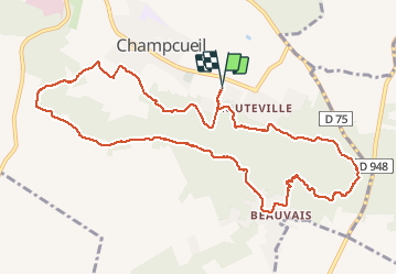
Champcueil à Loutteville

gentileadriano
User

Length
11.5 km

Max alt
153 m

Uphill gradient
211 m
Km-Effort
14.3 km

Min alt
78 m

Downhill gradient
211 m
Boucle
Yes
Creation date :
2021-02-18 07:52:53.547
Updated on :
2021-02-19 18:20:14.886
2h40
Difficulty : Easy

FREE GPS app for hiking
 SityTrail
IGN / Geographical institutes
SityTrail Plus
The world is yours!
About
Trail Walking of 11.5 km to be discovered at Ile-de-France, Essonne, Champcueil. This trail is proposed by gentileadriano.
Positioning
Country:
France
Region :
Ile-de-France
Department/Province :
Essonne
Municipality :
Champcueil
Location:
Unknown
Start:(Dec)
Start:(UTM)
460085 ; 5373169 (31U) N.
Comments