


La raye par la Baume Cornilliane

alinetpierre
User
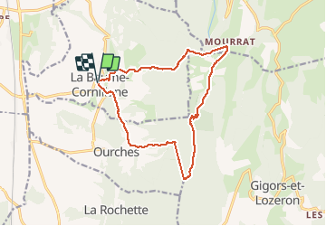

Length
15.3 km

Max alt
1004 m

Uphill gradient
825 m
Km-Effort
26 km

Min alt
315 m

Downhill gradient
824 m
Boucle
Yes
Creation date :
2021-02-20 08:51:12.0
Updated on :
2021-02-20 13:26:34.704
3h28
Difficulty : Easy

FREE GPS app for hiking
 SityTrail
IGN / Geographical institutes
SityTrail Plus
The world is yours!
About
Trail Walking of 15.3 km to be discovered at Auvergne-Rhône-Alpes, Drôme, La Baume-Cornillane. This trail is proposed by alinetpierre.
Description
Belle balade chemin confortable
Positioning
Country:
France
Region :
Auvergne-Rhône-Alpes
Department/Province :
Drôme
Municipality :
La Baume-Cornillane
Location:
Unknown
Start:(Dec)
Start:(UTM)
661234 ; 4965304 (31T) N.
Comments