


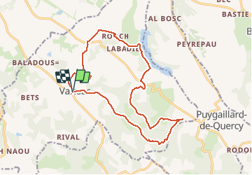
Vaissac Gouyre

Glurps
User

Length
18.6 km

Max alt
236 m

Uphill gradient
318 m
Km-Effort
23 km

Min alt
113 m

Downhill gradient
318 m
Boucle
Yes
Creation date :
2021-02-20 10:29:20.0
Updated on :
2021-02-20 15:04:49.537
4h16
Difficulty : Easy

FREE GPS app for hiking
 SityTrail
IGN / Geographical institutes
SityTrail Plus
The world is yours!
About
Trail Walking of 18.6 km to be discovered at Occitania, Tarn-et-Garonne, Vaïssac. This trail is proposed by Glurps.
Positioning
Country:
France
Region :
Occitania
Department/Province :
Tarn-et-Garonne
Municipality :
Vaïssac
Location:
Unknown
Start:(Dec)
Start:(UTM)
385353 ; 4876602 (31T) N.
Comments