


Anthisnes

tatous
User
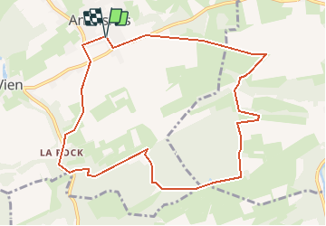

Length
9.8 km

Max alt
268 m

Uphill gradient
220 m
Km-Effort
12.8 km

Min alt
184 m

Downhill gradient
222 m
Boucle
Yes
Creation date :
2021-02-20 15:27:27.962
Updated on :
2021-02-21 15:51:41.177
--
Difficulty : Very easy

FREE GPS app for hiking
 SityTrail
IGN / Geographical institutes
SityTrail Plus
The world is yours!
About
Trail On foot of 9.8 km to be discovered at Wallonia, Liège, Anthisnes. This trail is proposed by tatous.
Description
Direction La Rock, contournement du Bois de Comblain.
Positioning
Country:
Belgium
Region :
Wallonia
Department/Province :
Liège
Municipality :
Anthisnes
Location:
Anthisnes
Start:(Dec)
Start:(UTM)
679063 ; 5595001 (31U) N.
Comments