


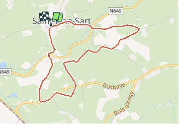
Du chemin du diable aux tourniquets

jbo1
User

Length
4.3 km

Max alt
201 m

Uphill gradient
82 m
Km-Effort
5.4 km

Min alt
165 m

Downhill gradient
79 m
Boucle
Yes
Creation date :
2021-02-21 09:53:11.741
Updated on :
2021-02-21 11:37:10.097
1h44
Difficulty : Very easy

FREE GPS app for hiking
 SityTrail
IGN / Geographical institutes
SityTrail Plus
The world is yours!
About
Trail Walking of 4.3 km to be discovered at Wallonia, Liège, Aubel. This trail is proposed by jbo1.
Photos

Positioning
Country:
Belgium
Region :
Wallonia
Department/Province :
Liège
Municipality :
Aubel
Location:
Aubel
Start:(Dec)
Start:(UTM)
698745 ; 5620711 (31U) N.
Comments