


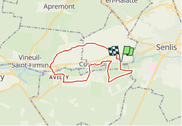
St nicolas d'Acy

Djaie60
User

Length
12.6 km

Max alt
70 m

Uphill gradient
111 m
Km-Effort
14.1 km

Min alt
41 m

Downhill gradient
111 m
Boucle
Yes
Creation date :
2021-02-21 12:20:16.0
Updated on :
2021-04-18 07:39:58.818
3h11
Difficulty : Easy

FREE GPS app for hiking
 SityTrail
IGN / Geographical institutes
SityTrail Plus
The world is yours!
About
Trail On foot of 12.6 km to be discovered at Hauts-de-France, Oise, Courteuil. This trail is proposed by Djaie60.
Positioning
Country:
France
Region :
Hauts-de-France
Department/Province :
Oise
Municipality :
Courteuil
Location:
Unknown
Start:(Dec)
Start:(UTM)
467506 ; 5449740 (31U) N.
Comments