


Charleval - Sainte Honorine

marcel.F
User
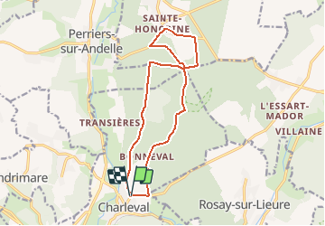

Length
13.6 km

Max alt
160 m

Uphill gradient
213 m
Km-Effort
16.5 km

Min alt
38 m

Downhill gradient
213 m
Boucle
Yes
Creation date :
2021-02-21 14:23:00.768
Updated on :
2021-02-21 14:41:55.689
3h00
Difficulty : Medium

FREE GPS app for hiking
 SityTrail
IGN / Geographical institutes
SityTrail Plus
The world is yours!
About
Trail On foot of 13.6 km to be discovered at Normandy, Eure, Charleval. This trail is proposed by marcel.F.
Description
Départ cimetière de Charleval
Positioning
Country:
France
Region :
Normandy
Department/Province :
Eure
Municipality :
Charleval
Location:
Unknown
Start:(Dec)
Start:(UTM)
382873 ; 5470396 (31U) N.
Comments