


angel

manumax
User
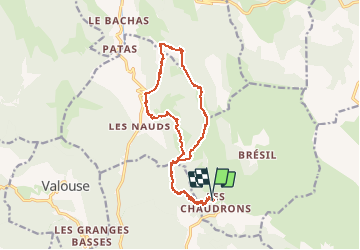

Length
16.7 km

Max alt
1383 m

Uphill gradient
1120 m
Km-Effort
32 km

Min alt
666 m

Downhill gradient
1111 m
Boucle
Yes
Creation date :
2021-02-21 08:51:23.408
Updated on :
2021-02-21 14:24:47.774
5h33
Difficulty : Very easy

FREE GPS app for hiking
 SityTrail
IGN / Geographical institutes
SityTrail Plus
The world is yours!
About
Trail Walking of 16.7 km to be discovered at Auvergne-Rhône-Alpes, Drôme, Chaudebonne. This trail is proposed by manumax.
Positioning
Country:
France
Region :
Auvergne-Rhône-Alpes
Department/Province :
Drôme
Municipality :
Chaudebonne
Location:
Unknown
Start:(Dec)
Start:(UTM)
678454 ; 4925306 (31T) N.
Comments