Trail Walking Bouilland - 
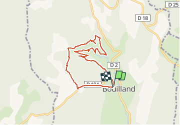
La grande Dore-Bouilland - Photo
 mpstoop
mpstoop

User

© OpenStreetMap contributors
Length
Length
7.2 km
Max alt
Max alt
573 m
Uphill gradient
Uphill gradient
355 m
Km-Effort
Km-Effort  
11.9 km
Min alt
Min alt
410 m
Downhill gradient
Downhill gradient
354 m
Boucle
Boucle
Yes
Creation date :
2021-02-22 08:56:46.215
Updated on :
2021-02-22 09:45:02.773

(0 Reviews)

Walking
Walking
2h42
Difficulty : Medium

Scan this QR Code to open this trail in the SityTrail application

FREE GPS app for hiking

Logo SityTrail SityTrail

IGN / Geographical institutes

Download SityTrail from the App Store Download SityTrail from Google Play

Logo SityTrail SityTrail Plus

The world is yours!

Download SityTrail from the App Store Download SityTrail from Google Play Download SityTrail on Huawei AppGallery

About

Trail Walking of 7.2 km to be discovered at Bourgogne-Franche-Comté, Côte-d'Or, Bouilland. This trail is proposed by mpstoop.

Description

PROMENADE à grande partie hors sentier permettant de découvrir un lieu isolé paradisiaque..à condition de vérifier que le bétail n'est pas aux pâtures ce jour ( sinon demi tour, les sentiers abondent aux alentours ) prévoir une boussole , éviter une période de chasse, respecter les clôtures..ce petit détour transgressif  découvre un recoin qui simule un vallon post-glaciaire à 500m d'altitude . Bonne recherche !

Elevation profile

Photos

Positioning

Country:
France
Region :
Bourgogne-Franche-Comté
Department/Province :
Côte-d'Or
Municipality :
Bouilland
Location:
Unknown
Start:(UTM)
634560 ; 5221538 (31T) N.


Close
My subscriptions