


bol d'air

Nila81
User
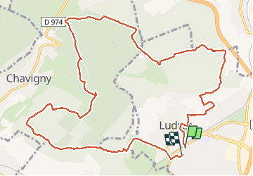

Length
14 km

Max alt
421 m

Uphill gradient
290 m
Km-Effort
17.9 km

Min alt
282 m

Downhill gradient
284 m
Boucle
Yes
Creation date :
2021-02-22 12:58:24.892
Updated on :
2021-02-22 16:10:31.639
3h09
Difficulty : Very easy

FREE GPS app for hiking
 SityTrail
IGN / Geographical institutes
SityTrail Plus
The world is yours!
About
Trail Walking of 14 km to be discovered at Grand Est, Meurthe-et-Moselle, Ludres. This trail is proposed by Nila81.
Description
22 fev
Positioning
Country:
France
Region :
Grand Est
Department/Province :
Meurthe-et-Moselle
Municipality :
Ludres
Location:
Unknown
Start:(Dec)
Start:(UTM)
290939 ; 5388881 (32U) N.
Comments