


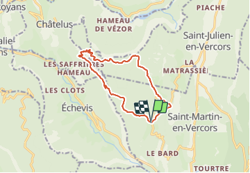
Pas de l_Allier et des Voûtes 12.5km

thonyc
User GUIDE

Length
12.4 km

Max alt
1259 m

Uphill gradient
853 m
Km-Effort
24 km

Min alt
784 m

Downhill gradient
849 m
Boucle
Yes
Creation date :
2021-02-23 08:37:19.335
Updated on :
2021-02-23 08:37:19.335
--
Difficulty : Unknown

FREE GPS app for hiking
 SityTrail
IGN / Geographical institutes
SityTrail Plus
The world is yours!
About
Trail Walking of 12.4 km to be discovered at Auvergne-Rhône-Alpes, Drôme, Saint-Martin-en-Vercors. This trail is proposed by thonyc.
Positioning
Country:
France
Region :
Auvergne-Rhône-Alpes
Department/Province :
Drôme
Municipality :
Saint-Martin-en-Vercors
Location:
Unknown
Start:(Dec)
Start:(UTM)
690764 ; 4988201 (31T) N.
Comments