Trail On foot Bitschwiller-lès-Thann - au dessus de  bitschwiller les thann - Photo

au dessus de bitschwiller les thann

© OpenStreetMap contributors
Length
Length
14.8 km
Max alt
Max alt
1186 m
Uphill gradient
Uphill gradient
925 m
Km-Effort
Km-Effort  
27 km
Min alt
Min alt
369 m
Downhill gradient
Downhill gradient
927 m
Boucle
Boucle
Yes
Creation date :
2021-02-23 08:38:57.726
Updated on :
2021-02-23 08:44:58.483

(0 Reviews)

On foot
On foot
--
Difficulty : Easy

Scan this QR Code to open this trail in the SityTrail application

FREE GPS app for hiking

Logo SityTrail SityTrail

IGN / Geographical institutes

Download SityTrail from the App Store Download SityTrail from Google Play

Logo SityTrail SityTrail World

The world is yours!

Download SityTrail from the App Store Download SityTrail from Google Play Download SityTrail on Huawei AppGallery

About

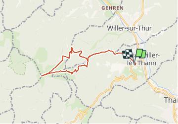
Trail On foot of 14.8 km to be discovered at Grand Est, Haut-Rhin, Bitschwiller-lès-Thann. This trail is proposed by senn francis.

Description

départ à coté de la maison d retraite de bitschwiller ,aller à la place Zundel puis se diriger cers la ferme du Roosberg ,monter au Roosberg (1198)descendre et monter au thanner hubel,longer la remontée mécanique et rejoindre le sentier qui descend à la place Zundel puis rejoindre le sentier de la montée qui vous ramène à Bitschwiller

Elevation profile

Positioning

Country:
France
Region :
Grand Est
Department/Province :
Haut-Rhin
Municipality :
Bitschwiller-lès-Thann
Location:
Unknown
Start:(UTM)
355818 ; 5298797 (32T) N.

Trails nearby

Trail Other activity Steinbach - lac du ballon - Photo
Other activity
rodabruna

Other activity

Very easy
(1)
Steinbach, Grand Est, Haut-Rhin, France
33 km | 64 km-effort
5h 1min
No
Trail Walking Bourbach-le-Haut - 2024-01-12_14h17m14_239006910 - Photo
Walking
GUIDE
mumu.larandonneuse

Walking

Difficult
Bourbach-le-Haut, Grand Est, Haut-Rhin, France
11.4 km | 18.5 km-effort
4h 12min
Yes
Trail Walking Thann - SityTrail - 2489713 - thann-roche--albert--grumbachkopf - Photo
Walking
argonneuweg

Walking

Medium
(1)
Thann, Grand Est, Haut-Rhin, France
7.6 km | 12 km-effort
2h 28min
Yes
Trail On foot Bitschwiller-lès-Thann - Bitschwiller les Thann - Rehbrunnel - Abri du Becherkopf - Roche Albert - Photo
On foot
patrickbeyrath

On foot

Medium
(1)
Bitschwiller-lès-Thann, Grand Est, Haut-Rhin, France
10.3 km | 16.4 km-effort
Unknown
Yes
Trail Walking Bitschwiller-lès-Thann - 68 Col du Hundsrück  - FA Gsang - retour ThannerHubel - Photo
Walking

Walking

Medium
(1)
Bitschwiller-lès-Thann, Grand Est, Haut-Rhin, France
11.2 km | 18.4 km-effort
3h 48min
Yes
Trail Walking Moosch - Moosch Haag - Photo
Walking
Estelle Handschin

Walking

Difficult
(1)
Moosch, Grand Est, Haut-Rhin, France
21 km | 0 m-effort
5h 27min
Yes
Trail Walking Moosch - Moos abri Faucon Crécerelle - Photo
Walking
ROPPJP

Walking

Very difficult
Moosch, Grand Est, Haut-Rhin, France
14.4 km | 24 km-effort
6h 32min
Yes
Trail Walking Willer-sur-Thur - Willer sur Thur col du Haag  - Photo
Walking
gamille67

Walking

Medium
Willer-sur-Thur, Grand Est, Haut-Rhin, France
29 km | 46 km-effort
6h 45min
Yes
Trail Walking Bitschwiller-lès-Thann - JD 16/20 Willer sur Thur - Ferme Auberge d'Ostein 15km 4h - Photo
Walking
argonneuweg

Walking

Difficult
Bitschwiller-lès-Thann, Grand Est, Haut-Rhin, France
15.1 km | 22 km-effort
4h 7min
Yes


Close
My subscriptions