


pic st michel

CABERMAT
User
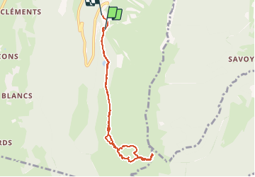

Length
8 km

Max alt
1965 m

Uphill gradient
546 m
Km-Effort
15.3 km

Min alt
1403 m

Downhill gradient
547 m
Boucle
No
Creation date :
2021-02-23 07:50:50.422
Updated on :
2021-02-23 10:47:13.923
1h48
Difficulty : Very easy

FREE GPS app for hiking
 SityTrail
IGN / Geographical institutes
SityTrail Plus
The world is yours!
About
Trail Touring skiing of 8 km to be discovered at Auvergne-Rhône-Alpes, Isère, Lans-en-Vercors. This trail is proposed by CABERMAT.
Positioning
Country:
France
Region :
Auvergne-Rhône-Alpes
Department/Province :
Isère
Municipality :
Lans-en-Vercors
Location:
Unknown
Start:(Dec)
Start:(UTM)
705187 ; 4998670 (31T) N.
Comments