


Labatie D'Andaure

Monjean
User

Length
19.4 km

Max alt
1062 m

Uphill gradient
859 m
Km-Effort
31 km

Min alt
491 m

Downhill gradient
858 m
Boucle
Yes
Creation date :
2021-02-23 07:48:23.841
Updated on :
2021-02-23 14:18:47.561
6h01
Difficulty : Very easy

FREE GPS app for hiking
 SityTrail
IGN / Geographical institutes
SityTrail Plus
The world is yours!
About
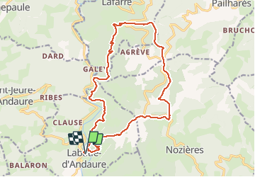
Trail Walking of 19.4 km to be discovered at Auvergne-Rhône-Alpes, Ardèche, Labatie-d'Andaure. This trail is proposed by Monjean.
Positioning
Country:
France
Region :
Auvergne-Rhône-Alpes
Department/Province :
Ardèche
Municipality :
Labatie-d'Andaure
Location:
Unknown
Start:(Dec)
Start:(UTM)
617807 ; 4987027 (31T) N.
Comments