


Villers 23.02.2021

RM21700
User
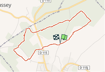

Length
4.9 km

Max alt
422 m

Uphill gradient
84 m
Km-Effort
6 km

Min alt
370 m

Downhill gradient
81 m
Boucle
Yes
Creation date :
2021-02-23 14:24:08.146
Updated on :
2021-02-23 16:35:07.289
1h10
Difficulty : Easy

FREE GPS app for hiking
 SityTrail
IGN / Geographical institutes
SityTrail Plus
The world is yours!
About
Trail Walking of 4.9 km to be discovered at Bourgogne-Franche-Comté, Côte-d'Or, Villers-la-Faye. This trail is proposed by RM21700.
Positioning
Country:
France
Region :
Bourgogne-Franche-Comté
Department/Province :
Côte-d'Or
Municipality :
Villers-la-Faye
Location:
Unknown
Start:(Dec)
Start:(UTM)
642467 ; 5219286 (31T) N.
Comments