


Ponsas

raygautier
User
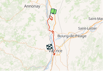

Length
60 km

Max alt
355 m

Uphill gradient
773 m
Km-Effort
70 km

Min alt
102 m

Downhill gradient
800 m
Boucle
No
Creation date :
2021-02-23 09:38:08.0
Updated on :
2021-02-23 18:10:28.283
7h16
Difficulty : Unknown

FREE GPS app for hiking
 SityTrail
IGN / Geographical institutes
SityTrail Plus
The world is yours!
About
Trail Walking of 60 km to be discovered at Auvergne-Rhône-Alpes, Drôme, Ponsas. This trail is proposed by raygautier.
Positioning
Country:
France
Region :
Auvergne-Rhône-Alpes
Department/Province :
Drôme
Municipality :
Ponsas
Location:
Unknown
Start:(Dec)
Start:(UTM)
644337 ; 5002268 (31T) N.
Comments