


amonines 28 kms

ochelen
User
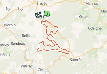

Length
28 km

Max alt
577 m

Uphill gradient
704 m
Km-Effort
38 km

Min alt
260 m

Downhill gradient
700 m
Boucle
Yes
Creation date :
2021-02-25 08:45:39.366
Updated on :
2021-02-25 08:46:57.228
--
Difficulty : Easy

FREE GPS app for hiking
 SityTrail
IGN / Geographical institutes
SityTrail Plus
The world is yours!
About
Trail Equestrian of 28 km to be discovered at Wallonia, Luxembourg, Érezée. This trail is proposed by ochelen.
Description
Balade cheval
Positioning
Country:
Belgium
Region :
Wallonia
Department/Province :
Luxembourg
Municipality :
Érezée
Location:
Amonines
Start:(Dec)
Start:(UTM)
682609 ; 5571551 (31U) N.
Comments