


refuge de l'alp de Villars

Arthur Robin
User

Length
4.7 km

Max alt
2088 m

Uphill gradient
416 m
Km-Effort
8.9 km

Min alt
1674 m

Downhill gradient
15 m
Boucle
No
Creation date :
2021-02-25 10:44:35.882
Updated on :
2021-02-26 17:12:27.149
2h41
Difficulty : Easy

FREE GPS app for hiking
 SityTrail
IGN / Geographical institutes
SityTrail Plus
The world is yours!
About
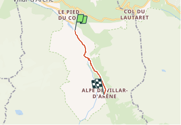
Trail Touring skiing of 4.7 km to be discovered at Provence-Alpes-Côte d'Azur, Hautes-Alpes, Villar-d'Arêne. This trail is proposed by Arthur Robin.
Positioning
Country:
France
Region :
Provence-Alpes-Côte d'Azur
Department/Province :
Hautes-Alpes
Municipality :
Villar-d'Arêne
Location:
Unknown
Start:(Dec)
Start:(UTM)
292372 ; 4989390 (32T) N.
Comments