


Orcines Villars 2

jeanic63
User
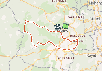

Length
15 km

Max alt
1137 m

Uphill gradient
442 m
Km-Effort
21 km

Min alt
711 m

Downhill gradient
446 m
Boucle
Yes
Creation date :
2021-02-27 17:56:36.649
Updated on :
2021-03-01 17:26:07.171
--
Difficulty : Medium

FREE GPS app for hiking
 SityTrail
IGN / Geographical institutes
SityTrail Plus
The world is yours!
About
Trail On foot of 15 km to be discovered at Auvergne-Rhône-Alpes, Puy-de-Dôme, Orcines. This trail is proposed by jeanic63.
Description
départ Orcines parking Mairie Eglise
Positioning
Country:
France
Region :
Auvergne-Rhône-Alpes
Department/Province :
Puy-de-Dôme
Municipality :
Orcines
Location:
Unknown
Start:(Dec)
Start:(UTM)
500915 ; 5069991 (31T) N.
Comments