


Rochebaudin - Boucle - 18km d850

manumax
User
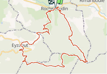

Length
17.6 km

Max alt
966 m

Uphill gradient
849 m
Km-Effort
29 km

Min alt
326 m

Downhill gradient
852 m
Boucle
Yes
Creation date :
2021-02-28 08:32:02.177
Updated on :
2022-04-21 15:34:10.174
5h46
Difficulty : Very easy

FREE GPS app for hiking
 SityTrail
IGN / Geographical institutes
SityTrail Plus
The world is yours!
About
Trail Walking of 17.6 km to be discovered at Auvergne-Rhône-Alpes, Drôme, Rochebaudin. This trail is proposed by manumax.
Positioning
Country:
France
Region :
Auvergne-Rhône-Alpes
Department/Province :
Drôme
Municipality :
Rochebaudin
Location:
Unknown
Start:(Dec)
Start:(UTM)
661325 ; 4938334 (31T) N.
Comments