


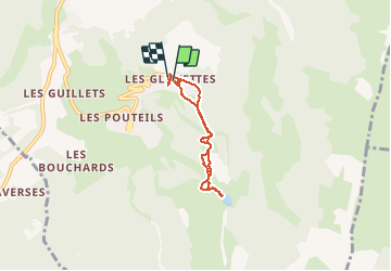
Les Glovettes- pré des prés- Les Glovettes

fredtruc27
User

Length
5.7 km

Max alt
1520 m

Uphill gradient
328 m
Km-Effort
10 km

Min alt
1216 m

Downhill gradient
324 m
Boucle
Yes
Creation date :
2021-02-28 09:30:35.95
Updated on :
2021-02-28 16:54:39.903
2h00
Difficulty : Medium

FREE GPS app for hiking
 SityTrail
IGN / Geographical institutes
SityTrail Plus
The world is yours!
About
Trail Walking of 5.7 km to be discovered at Auvergne-Rhône-Alpes, Isère, Villard-de-Lans. This trail is proposed by fredtruc27.
Description
Effectuée fin février avec un enneigement partielle. la randonnée n'est pas difficile techniquement. c'est un aller-retour des Glovettes au lac du pré des prés.
Positioning
Country:
France
Region :
Auvergne-Rhône-Alpes
Department/Province :
Isère
Municipality :
Villard-de-Lans
Location:
Unknown
Start:(Dec)
Start:(UTM)
701892 ; 4991879 (31T) N.
Comments