


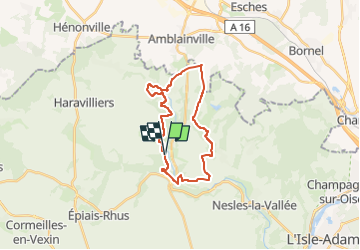
Ménouville, Labbeville, Aronville (Amblainville sud)

philberard95
User

Length
21 km

Max alt
130 m

Uphill gradient
300 m
Km-Effort
25 km

Min alt
48 m

Downhill gradient
300 m
Boucle
Yes
Creation date :
2021-02-28 18:55:28.643
Updated on :
2023-01-11 10:55:38.408
5h39
Difficulty : Very difficult

FREE GPS app for hiking
 SityTrail
IGN / Geographical institutes
SityTrail Plus
The world is yours!
About
Trail Walking of 21 km to be discovered at Ile-de-France, Val-d'Oise, Menouville. This trail is proposed by philberard95.
Positioning
Country:
France
Region :
Ile-de-France
Department/Province :
Val-d'Oise
Municipality :
Menouville
Location:
Unknown
Start:(Dec)
Start:(UTM)
435123 ; 5444586 (31U) N.
Comments